Modern vehicles are rolling computers, producing enormous amounts of valuable data concerning their operations and surroundings. When integrated with other data sources, they present a multitude of opportunities for the development of valuable, data-driven services. However, these diverse data sources, including driving behavior data, weather data, and accident hotspot data, are usually owned by various stakeholders.
Consequently, facilitating seamless data sharing among these potential stakeholders for service development becomes paramount. In addition to numerous data sharing challenges, PISTIS tackles the associated technological and social complexities to ensure effective resolution.
The automotive data hub delves deep into enhancing data sharing to support a use case centered around driving style and risk assessment. The use case concept revolves around alerting drivers to potential hazards along their driving route. These hazards are extracted from data provided by different stakeholders (using the PISTIS platform).
In the use case, drivers, acting as users of the service, interact with a digital platform to request predictions on traffic safety risks, providing information such as their location, driving direction, and speed. Subsequently, they receive information on traffic safety-related events along their driving route, with their individual driving risk depending on their driving style factored in. If the risk surpasses a predefined threshold, users are alerted, prompting them to adopt a safer driving approach.
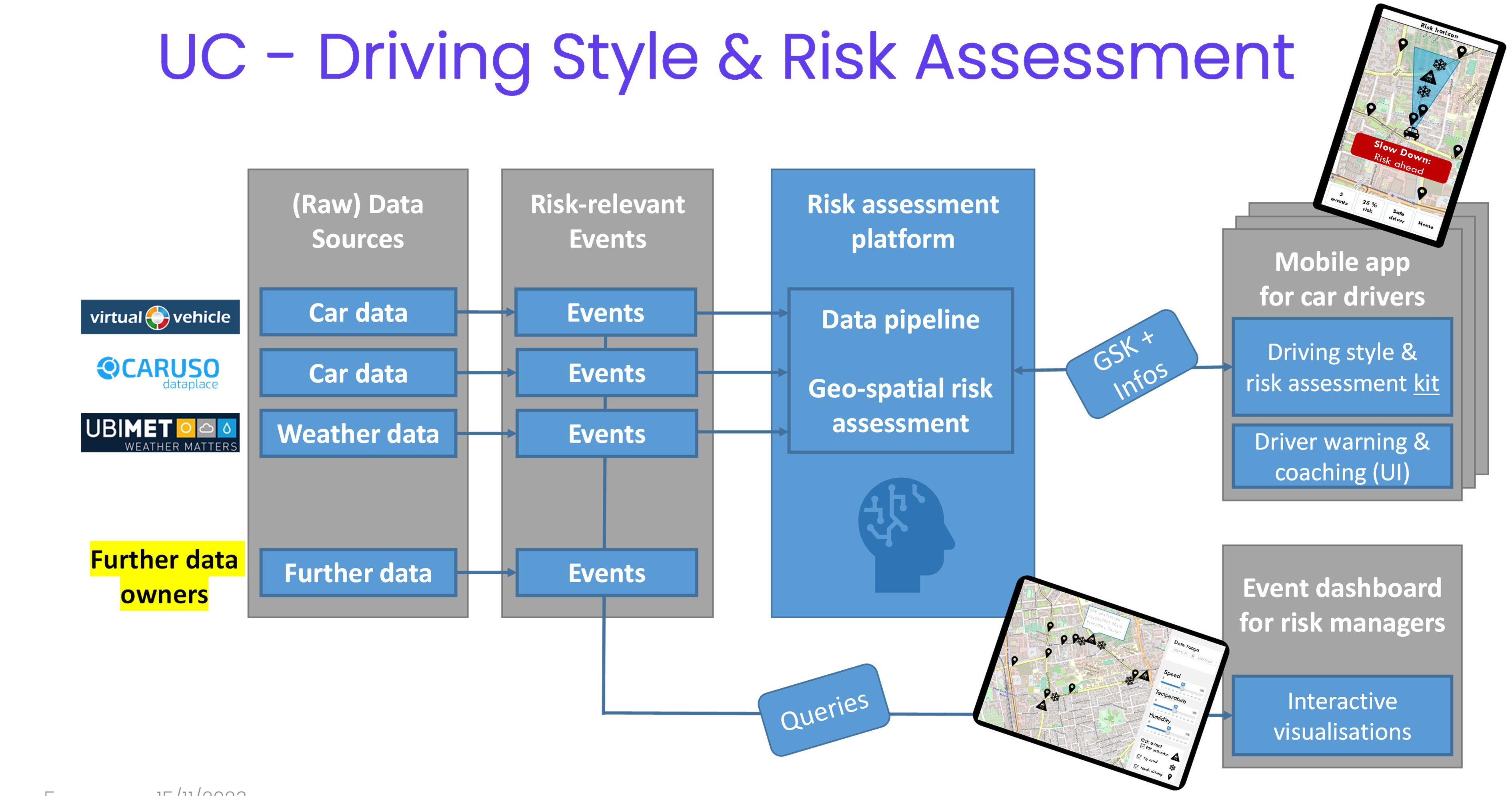
PISTIS are enabling a process where vehicle data, collected through the collaborative efforts of the project partners VIF and CARUSO, is integrated with weather data from UBIMET. This integration aims to extract events relevant to driving risk, such as instances of aggressive braking or slippery roads. These identified risk-relevant events will then serve as input to a dedicated risk assessment pipeline. To make this information accessible, the project includes two demonstrator applications. The first is a mobile application tailored for car drivers that provides (real-time) warnings about potential driving risks along their routes. The second demonstrator application is an interactive web dashboard designed for traffic risk managers, allowing them to interact with the extracted risk-relevant events on a geographic map derived from the shared data. The mobile application serves as a proactive tool for drivers to increase their awareness and promote safer driving practices, while the dashboard enables risk managers to engage with and respond to the dynamic risk landscape based on the integrated data sets.